 This page is part of the companion website to my book Toronto: Transformations in a City and its Region, published by UPenn Press.
Founding and Early Settlement
If Toronto could think, it would surely be confused about who it is because almost from the moment of its founding in 1793 its name or boundaries or both have repeatedly been changed. Chapter 2 in my book describes these changes. Here are some additional images to supplement those in that chapter.
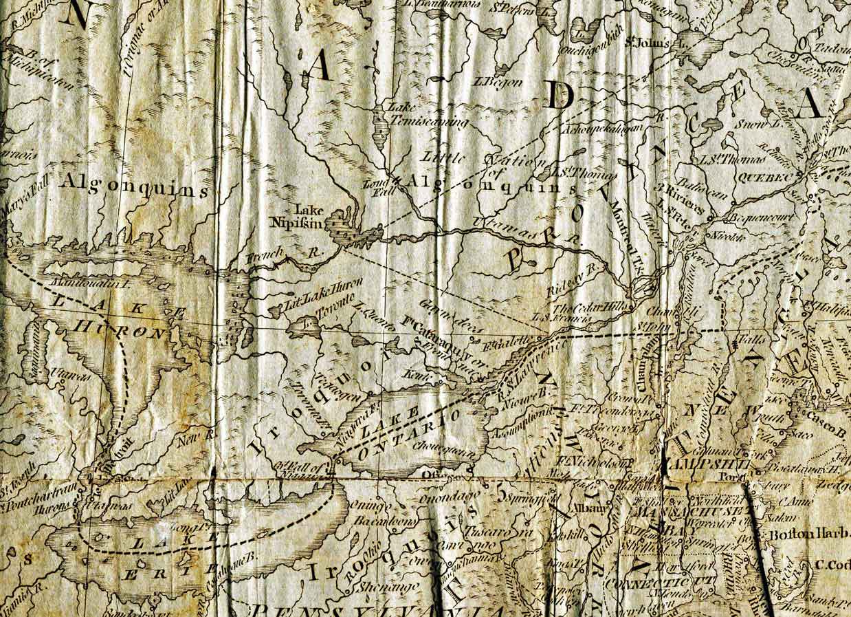
First, here’s a slightly larger version of Salmon’s 1785 map of North America than the part I include in the book. It shows Lake Erie and some of the Atlantic Coast near Boston. Apart from its historical interest, I find this remarkable for the astonishing quality of the engraving. Click on it to enlarge.
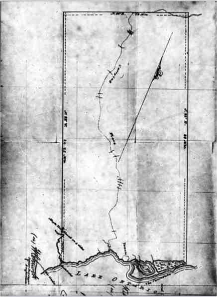
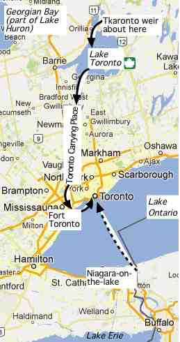 On the left is the survey of the Toronto Purchase, actually made about 15 years after the actual purchase of 1787, which was apparently based on written descriptions, so it’s little wonder the land claim of the Mississauga Indians arose a couple of centuries later. Lake Ontario is at the bottom, with Toronto Harbour at the right. The Humber River runs through the center of the purchased area. The map on the right shows how Toronto’s name was transferred from a fishing weir on a lake used by fur traders, to the name of the lake (now Lake Simcoe), to the portage or carrying place of the Humber River, to the fort near the mouth of that on the shore of Lake Ontario, and then, because that was the name associated with the purchase of land from the Mississaugas, to the initial settlement of Toronto when Simcoe and the Queen’s Rangers moved the capital of Upper Canada here from Niagara-on-the-Lake (then called Newark) in the summer of 1793. [The origins of the name ‘Toronto’ are discussed in A. Rayburn, “The Real Story of How Toronto got its Name.”
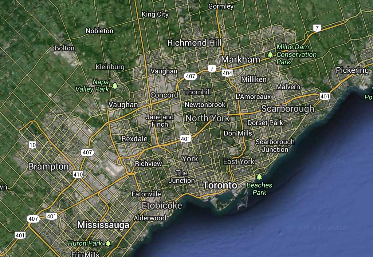
The more or less regular grid survey that was initiated by Simcoe soon after he founded Toronto has had a lasting influence on the geography of the metropolitan area, as is apparent from this image from Google Maps, which shows major arterial roads in yellow. These follow the original survey for concession and side roads. The initial base line was set up about where the name Toronto is, with Yonge Street perpendicular to it. A second base line, also parallel to the shore of Lake Ontario was set up in what is now Mississauga, and the two surveys meet at an acute angle. Otherwise the system is remarkably regular.
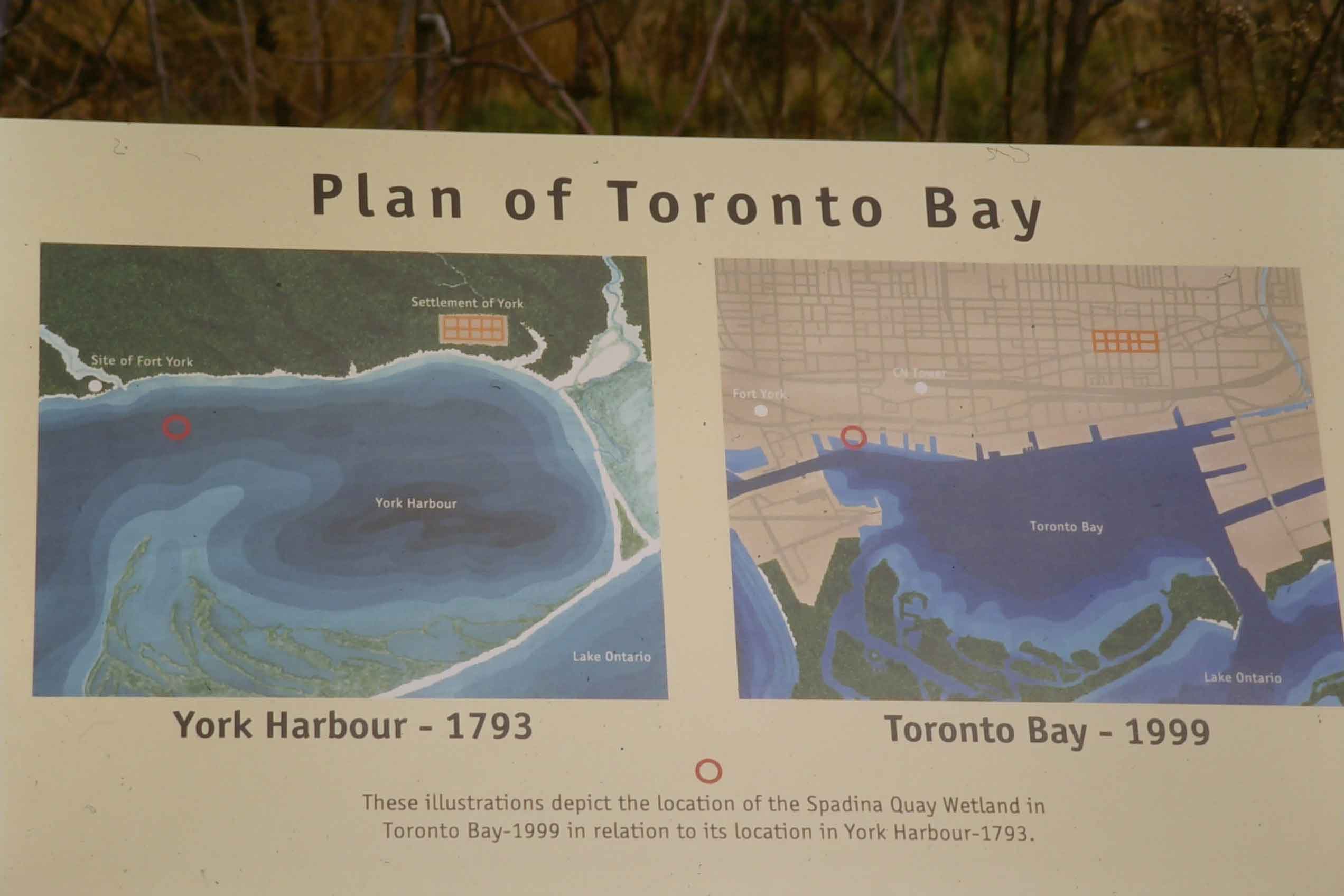 These two maps, on a panel at a tiny wetlands park on the shore of Lake Ontario at the foot of Spadina Avenue, show the original site of Toronto, as set out according to Simcoe’s instructions, and its current location relative to the shoreline (there haven’t been many changes since 1999). The site was in a harbor sheltered by what was then a spit, and with a relatively narrow entrance that would be guarded by Fort York (the white dot in the upper left), now reconstructed as a heritage site surrounded by expressway ramps. The mouth of the Don River is on the top right. A major storm in the 1840s broke through the spit to create Toronto Islands. There has subsequently been substantial landfill to extend the shoreline.
City of Toronto 1834 to 2014
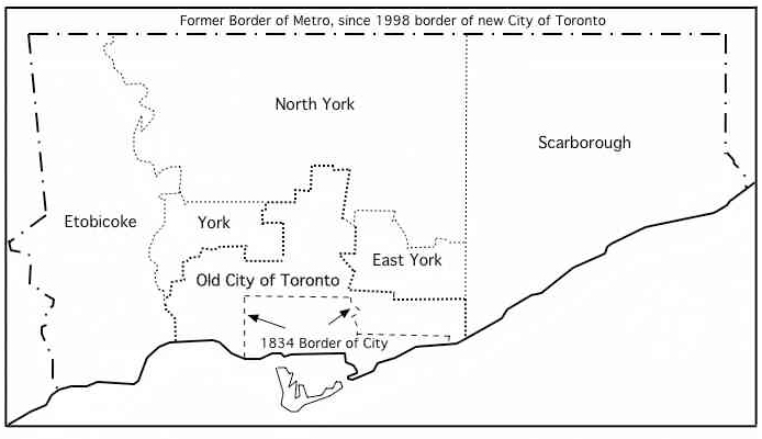
This map shows the border of the old City of Toronto in 1834, when it was incorporated and replaced the Town of York. Until 1912 it expanded by annexing a number of small adjacent municipalities, and apart from a few changes in the 1960s, it stayed that shape until 1998, when it was amalgamated with the the adjacent municipalities of Scarborough, North York, East York, York and Etobicoke to replace what had been Metropolitan Toronto and to create the new City of Toronto. All the internal boundaries have legally disappeared but the old place names are still widely used.
Contemporary maps showing the old City as it grew over the course of the 19th century can be seen at the Toronto Archives website at http://www.toronto.ca/archives/1834.htm
Greater Toronto Area, Census Metropolitan Area, Greater Golden Horseshoe
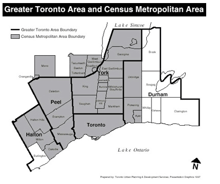
This map shows the boundaries of the Greater Toronto Area as they are usually understood (defined by the outer borders of the regions of Halton, Peel, York and Durham that surround the City of Toronto), though it has never had any formal legal or political status. The Census Metropolitan Area is shaded in grey. Some reports about the region use the the GTA as the basis for analysis and others use the CMA, and there are significant differences in population between the two.
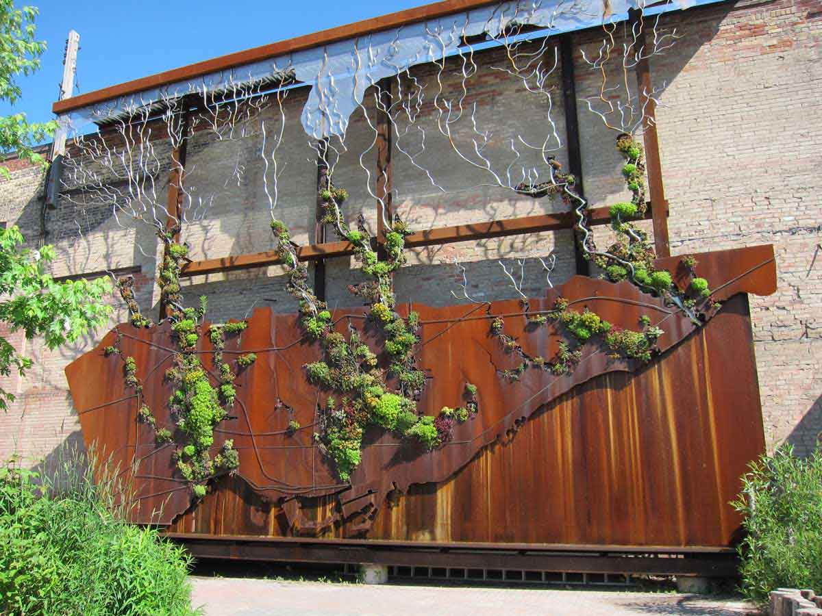
Neither of these correspond to the Toronto bioregion, defined by watersheds of the rivers that flow through the City and the region. The splendid installation in the photo below is at Toronto Brickworks, where many of the bricks made for building late 19th and early 20th century Toronto were made and which is now a demonstration site for all things green. It shows the bioregion as a living wall, with plants snaking up the major rivers (Humber River on the left, Don in the centre, Rouge on the right).
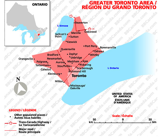
 By this point it should be clear that there is no consistent, enduring definition of either the City of Toronto or the Toronto region. A quick search for maps of the GTA reinforces this. For instance, the one on the left is from the Federation of Ontario Bed and Breakfast Associations, the one on the right is from Industry Canada, a federal agency. In popular usage the GTA is simply the area centred on Toronto.
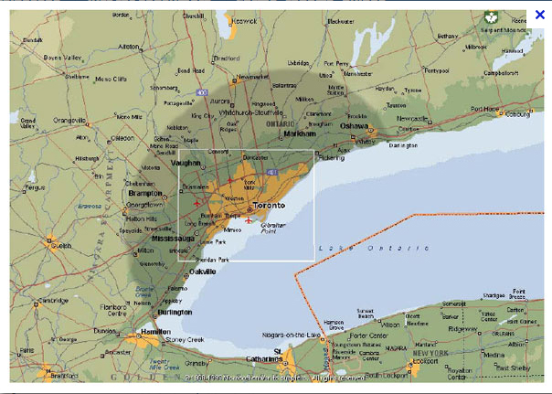
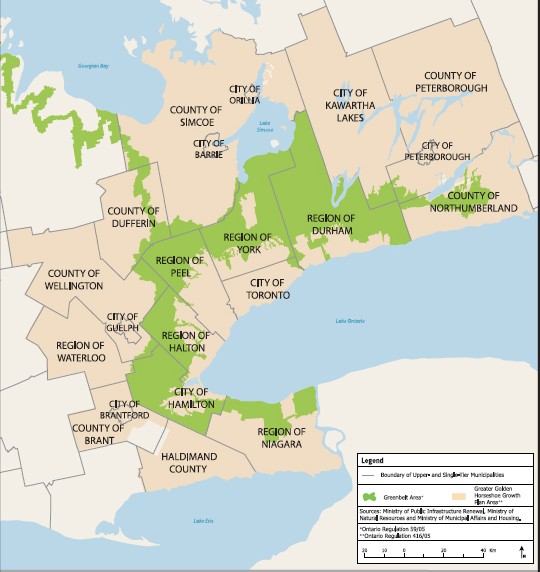
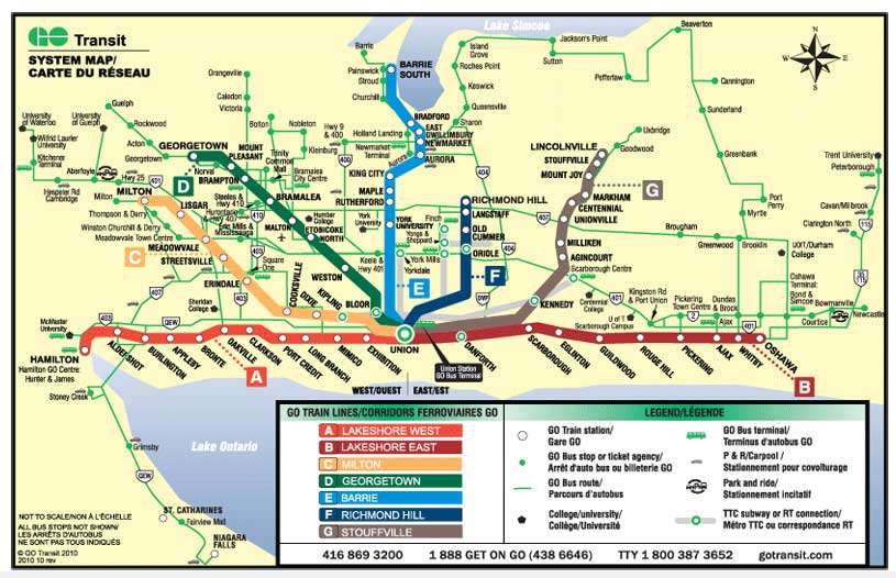
The GTA has never been given any formal legal status, and has now been surpassed by the Greater Golden Horseshoe, which is the region around Toronto now formally identified in the Province of Ontario’s Growth 2006 Growth Plan for regional planning purposes (discussed in Chapter 9 and available here) It corresponds closely to the area serviced by GO transit – the regional train and bus transit service – shown in the map below.
Some population numbers 2011
Old City of Toronto – 676,000 (for 2001, last date this was included in Canadian Census); new City of Toronto (Metro)- 2,615,000; CMA – 5,584,000; GTA – 6,054,00; Greater Toronto and Hamilton Area – 6,574,000.
Cross Border and Global Regions of Toronto
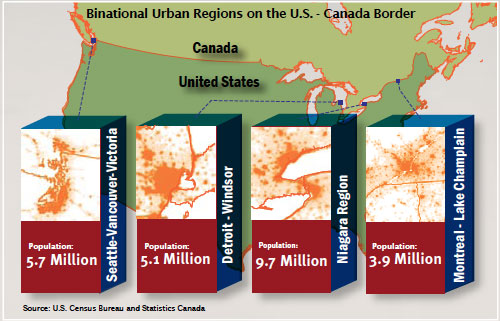
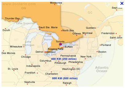 The fact that Toronto’s functional region does not stop at the U.S. border is acknowledged by Canadians and Americans alike. The map on the left came from from the Greater Toronto Marketing Association website about 2010 and shows Toronto at the centre of circles that include Boston, New York, Washington, Chicago (the map has been removed but the text on the website makes the same point). The diagram below is from Regional Institute at SUNY Buffalo, (http://www.regional-institute.buffalo.edu) and shows four binational Canadian/U.S. urban regions, of which the Niagara Region of Toronto-Buffalo is by far the largest in terms of population.
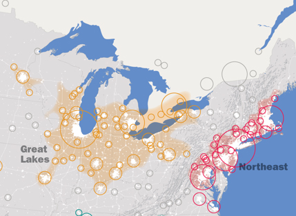 The Regional Planning Association (http://www.america2050.org/) has identified several megaregions in North America, and their map below shows Toronto at the eastern edge of a Great Lakes Megaregion (which combines Detroit-Windsor and the Niagara Region and includes Chicago and Minneapolis). I know of three reasons why this is not as fanciful as it might seem. First, Toronto shares the Great Lakes with Chicago, Milwaukee, Detroit, Cleveland and Buffalo. Second, the Toronto region is ecologically at the eastern edge of the tall grass prairie (there are remnants around Rice Lake, for example), and to that extent it is a part of the mid-West. And third, on my not infrequent drives across the continent I see a lot of trucks with Ontario plates as far as Illinois, but almost none further west.
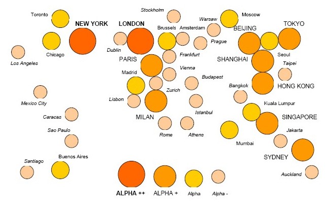
Once you start pushing out the borders of the Toronto region, in the context of immigration patterns and movements of capital you soon reach around the world (see Chapter 8). Toronto is considered a high ranking command centre in global finance. This diagram is from the Globalization and World Cities research group and shows Toronto as an Alpha city in the network of world cities, when it ranked 14th in the world. The data were updated for 2010, when Toronto ranked 13th. I don’t suppose things have changed much since then, in spite of the surge of office construction in Toronto.